


Garmin essais 1 du 20

lemuid
User
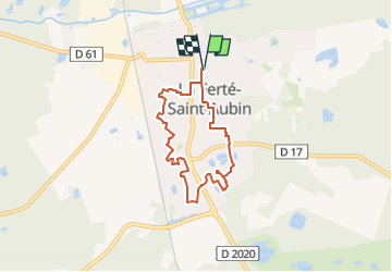

Length
6.2 km

Max alt
134 m

Uphill gradient
56 m
Km-Effort
6.9 km

Min alt
105 m

Downhill gradient
56 m
Boucle
Yes
Creation date :
2025-01-20 13:00:58.661
Updated on :
2025-01-20 13:02:04.683
1h34
Difficulty : Easy

FREE GPS app for hiking
 SityTrail
IGN / Geographical institutes
SityTrail Plus
The world is yours!
About
Trail On foot of 6.2 km to be discovered at Centre-Loire Valley, Loiret, La Ferté-Saint-Aubin. This trail is proposed by lemuid.
Positioning
Country:
France
Region :
Centre-Loire Valley
Department/Province :
Loiret
Municipality :
La Ferté-Saint-Aubin
Location:
Unknown
Start:(Dec)
Start:(UTM)
420758 ; 5285710 (31T) N.
Comments